Chasing history through the Northwest Passage
Voyaging in the Northwest Passage with Adventure Canada. We’re going to do it again next August. Photos by Sheena Fraser McGoogan.
DAY THREE: Gjoa Haven
Monday, Sept. 7
Exhilarated. The word surfaced again
and again as people arrived back from Gjoa Haven. Were they excited by the
zodiac ride through choppy waters? No, one woman answered. The teenagers! the
young people who drove the cultural presentation and subsequent entertainment
at the community centre. All those teenagers, square-dancing to country and
western swing. Their madcap, exulting energy. And the other activities – the
mayor’s welcome, the chance to sample bannock, the hike round town – also
contributed hugely.
We had gone ashore after a morning of
talks and workshops, and then a convivial lunch featuring guests from the
community. This Inuit settlement (population 1200 to 1300), soon to become home
to a new Franklin Expedition Centre, arose with the arrival of Roald Amundsen
in the Gjoa (1903) and the subsequent establishing of a Hudson’s Bay Company
post (1927).
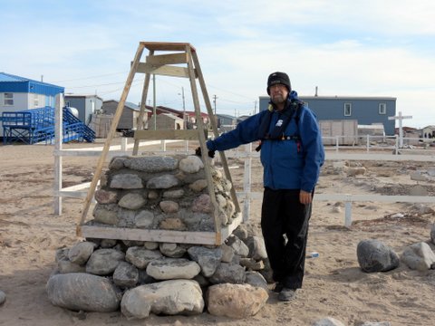
Local news surfaced out front of the
cultural centre: the Gjoa Haven cairn is being rebuilt. The original was
destroyed in 2010 after a report (false, as it turned out) that it sheltered documents relating to John Franklin. Louie
Kamookak, hailed for contributing to the 2014 discovery of Erebus, is
overseeing the reconstruction of the town landmark. Kamookak was out on the
land when we reached Gjoa, but there stood the evidence,
half-completed. And Kenneth Kaloon, one of the young men (born 1993) who guided
visitors around town, affirmed that Kamookak was supervising the rebuilding of
the cairn. [Within days of our visit, he had completed this task.]

Most passengers from the Ocean
Endeavour, having debarked from zodiacs onto a floating pontoon, hiked through
town and climbed a hill to see a wooden memorial erected by the Norwegian
government in honour of Roald Amundsen. The first explorer to navigate the
Northwest Passage from one end to the other, Amundsen had lingered in Gjoa
Haven to take magnetic observations of the ever-shifting North Magnetic Pole, pin-pointed
in 1831 by James Clark Ross. In the late afternoon, looking out over Gjoa
Haven, it was easy to see why Amundsen had described this bay as “the finest little
harbor in the world.”
Come evening, voyagers capped an eventful day with a viewing of Franklin’s
Lost Ships, a stellar documentary about the 2014 discovery of Erebus.
DAY
FOUR: Bellot Strait
Tuesday,
September 8
Coningham Bay and Bellot Strait. Where
to begin? Lovers of wildlife got a rush out of the zodiac cruise into the bay. They
returned from an early afternoon excursion exclaiming. Amazing! Fantastic!
Polar bears! One voyager declared that the best moment came when a big male swam
across the narrows and climbed out in front of the zodiac. Absolutely wonderful,
said another passenger. I don’t need to see them up close. For that, I can look
at the photos by the professionals. But to see them out in their natural
habitat . . . that really is fantastic.
Veteran staffers had worried that the swell
would prevent the outing. But the wind dropped as the ship approached the bay
and away went the zodiacs. Later, not long after 5 pm, the ship entered Bellot
Strait, a thirty-six-kilometre-long channel, roughly 1.5 kilometres wide, which
traces the northern extent of the North American continent. Both sides of the
strait turned up animals. We saw polar bears climbing around on the rocks. We
saw eighteen or twenty muskox on a high plateau. Graeme Gibson spotted one
hard-to-see Arctic fox. He was telling me about this when harp seals swam past
on the starboard side, and sea mammal expert Deanna Spitzer took to the
microphone to keep us informed.
All the land north of this strait is Arctic
archipelago. By the time we passed Sibley Point, the northernmost extension of the
Canadian mainland, jutting in from starboard, geologist Marc St. Onge was dashing
back and forth across the top deck, leading a number of enthusiastic followers.
He explained that the strait is an east-west transect through Boothia Uplift. Some
of these rock structures date back 395 million years to the formation of the
Pangea supercontinent.
Before any of this, we heard from
assistant expedition leader David Reid on polar bears and veteran journalist Aaron
Spitzer on the political structure of Nunavut. As to history, the strait was discovered
and mapped in 1852 by William Kennedy, who named it after his
second-in-command, Joseph-Rene Bellot, a great favorite of Jane, Lady Franklin. At one point, as I stood alone on an
upper deck, I found myself imagining these two guiding dog sleds through these environs when they were covered with ice.
At the western end of the strait we had just
navigated, they debated which way to go. Bellot wanted to turn south down the
Boothia coast, as directed by Lady Franklin. But Kennedy prevailed and the men
proceeded west and north . . . and ended up exploring areas that had already
been searched. If they had gone south, they would almost certainly have reached
the northeast coast of King William Island and learned what had happened to the
Franklin expedition.
